
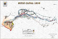
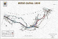
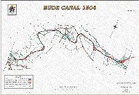
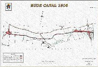
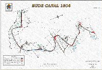
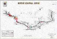
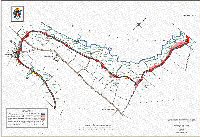
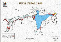
In 1902, when the Stratton and Bude Urban District Council purchased from the Bude Harbour and Canal Company the canal and adjacent property from the Bude Breakwater to the now Lower Tamar Lake, to provide a clean and potable water supply, a series of plans were produced with accompanying explanatory notes. These documents were prepared by W J Dunbar, a civil engineer of Liskeard. The plans were based on the plans of the canal held by the Canal Company. There are eight plans, the originals are about A1 in size and are in a bound book. The plans and explanatory notes are held by Bude-Stratton Town Council and are available to view by prior arrangement.
In 2006, Bude Canal and Harbour Society obtained a grant from ‘Awards for All’ and Bude-Stratton Town Council to complete the project to redraw the maps. The project has been expanded by the society to develop an Archive Display to include other items as well as the Canal Maps and notes.
This book contains all eight plans with the relevant surveyor’s notes and comments on each plan. They are an interesting insight of the structure of Bude and the canal corridor in the early 1900’s.
BCHS wish to thank Bude-Stratton Town Council for giving their consent to redraw these maps and for the grant towards the cost of completing that task. Thanks also to ‘Awards for All’ for their grant towards the cost of redrawing the maps and producing the wider Archive Display which will be developed to give a picture of the heritage that is the Bude Canal. Finally, thanks to Mr David Martin of Martin Group Services, Bude for his technical prowess and empathy in the completion of this project.
Bude Canal and Harbour Society
Registered Charity No. 1086646 July 2006
![]()

Please CLICK on the thumbnails below to access a full A4 colour pdf of each of the 8 maps, together with a front introduction sheet and the relevant surveryor's notes. See below if you wish to purchase proper mounted maps together with the relevant notes.
Canal Map 1
Canal Map 2
Canal Map 3
Canal Map 4
Canal Map 5
Canal Map 6
Canal Map 7
Canal Map 8