HISTORY
|
HISTORY |
|
About the Society History Features Bude Canal Project Newsletter - The Tub Boat Photos Maps Walks Books for Sale Links Members Section |
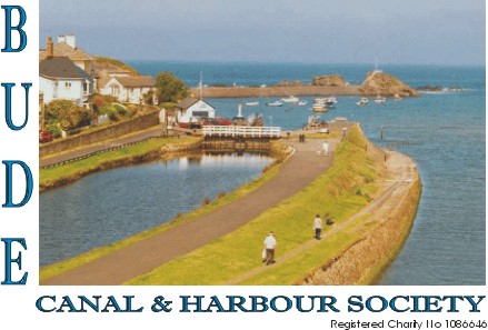
John Edyvean, a Cornishman, originally conceived the idea of the Bude Canal in 1774.
James Green estimated that the total cost of the construction of the canal and improvements to the harbour to £128,341. After consideration, the proposers applied for an Act of Parliament, which was obtained in 1819. The same year the Bude Harbour and Canal Company was formed, amongst the 330 shareholders was James Green who had been appointed engineer in charge of construction. Work commenced on 23rd July 1819 and was eventually completed in 1825, although the canal was in operation by 1823. The final cost was just below £120,000. The canal as built was 35 ½ miles in total and comprised of the main line from Bude to Blagdon Moor Wharf, near Holsworthy, with a branch from Red Post to Druxton Wharf, nr. Launceston and a feeder arm from the newly constructed Tamar Lake (now Lower Tamar Lake) to feed the canal with water. The canal was unique, in that it was constructed for agricultural purposes, the transporting of lime rich sand for the improving of soil. The original Breakwater was destroyed in a terrible storm in February 1838 and was replaced by the existing breakwater, which was radically different and longer. It was completed in 1843. The original sea lock was reconstructed in 1835 following storm damage and was enlarged to 116’ x 29’6” with a depth of water at the cill of 9’6”. This enlargement allowed vessels of up to 300 tons to enter the basin. (In the year 2000, the sea lock had a complete refurbishment with 2 new sets of gates, new cills and stabilising of the structure. Total cost ½ million pounds) This project was funded by E U Funds, English Heritage, NCDC, B.S.T.C. and IWA. As time passed by roads improved, the railway network was spreading into North Cornwall, and new chemical fertilisers became available. By 1879, the London and South Western Railway had reached Holsworthy. All these factors eventually affected the trade, which went into decline, and by 1891 it was so bad that the Canal Company obtained an Act of Parliament to abandon the branches from Red Post to Druxton and Brendon Moor to Blagdonmoor nr. Holsworthy. The end was near. The company retained the Harbour, the Barge Canal, the Tub Boat Canal to Tamar Lake the reservoir. The railway arrived at Bude on 10th August 1898. In 1902, the Canal Company sold their venture to the then Stratton and Bude Urban District Council. The Council used the upper reaches to provide a potable water supply for Bude and Stratton and thereby improve the public health of the area, for which they had received many rebutes from Public Health Authorities. The trading by sea continued through the early part of the 20th Century, but gradually declined. During the 1920’s the inland locks were de-gated and had concrete spillways installed, a move which was actually illegal, as it was done without the authority of an Act of Parliament which was required to remove the right of navigation to Helebridge. This was eventually legitimised by the Bude Stratton Urban District Act 1960. This Act also authorised the disposal of the canal from Helebridge to Vealand except for the Burmsdon Aqueduct and Burmsdon Farm Bridge and removed the requirement that Falcon Bridge should be opened as a swing bridge. The following years saw much of the canal from Marhamchurch to Vealand disappearing under plough and excavator. Falcon Bridge was replaced with a modern road bridge and consequently lowered thus reducing the passage under it to rowing boats, canoes and waterfowl!! The barge section from the Sea Lock to Helebridge Basin, is now owned by Cornwall Council and used for recreational pursuits. The Barge Workshop at Helebridge is owned by Bude Stratton Town Council (BSTC) and houses various larger artefacts given to the Town’s museum. It also currently houses the only known example of a Bude Canal tub boat, which is substantially complete, including its wheels.This has been purchased for £1 from the International Sailing Craft Association (ISCA). The BSTC has had the tub boat assessed by a marine archaeologist and a conservator to identify the correct and best way to keep the tub boat and what, if any, measures need to be taken to maintain the tub boat. This tub boat was recovered by ISCA from the canal in 1976 and is of national importance being an original wooden working canal boat. |